


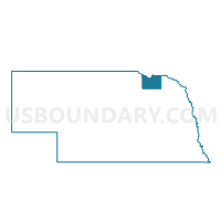
006 NIO Precinct, Knox County, Nebraska
About
Outline

Summary
| Unique Area Identifier | 613341 |
| Name | 006 NIO Precinct |
| County | Knox County |
| State | Nebraska |
| Area (square miles) | 164.60 |
| Land Area (square miles) | 157.36 |
| Water Area (square miles) | 7.24 |
| % of Land Area | 95.60 |
| % of Water Area | 4.40 |
| Latitude of the Internal Point | 42.77872670 |
| Longtitude of the Internal Point | -98.10702280 |
Maps


Graphs
Select a template below for downloading or customizing gragh for 006 NIO Precinct, Knox County, Nebraska


Neighbors
Neighoring Voting District (by Name) Neighboring Voting District on the Map
- 004 CTR Precinct, Knox County, NE
- 005 LDS Precinct, Knox County, NE
- 007 VDG Precinct, Knox County, NE
- Bristow - Mullen - Lynch - Bush Precinct, Boyd County, NE
- Precinct 4, Holt County, NE
- VTD precinct 1, Charles Mix County, SD
- VTD precinct 2, Charles Mix County, SD
- VTD-Springfield precinct 5, Bon Homme County, SD
Top 10 Neighboring County Subdivision (by Population) Neighboring County Subdivision on the Map
- Southwest Bon Homme UT, Bon Homme County, SD (713)
- Hill township, Knox County, NE (671)
- Niobrara township, Knox County, NE (431)
- Raymond township, Knox County, NE (207)
- Rouse township, Charles Mix County, SD (164)
- Ree township, Charles Mix County, SD (140)
- Union township, Knox County, NE (106)
- Sparta township, Knox County, NE (84)
- Bush township, Boyd County, NE (77)
- Harrison township, Knox County, NE (66)
Top 10 Neighboring Place (by Population) Neighboring Place on the Map
Top 10 Neighboring Unified School District (by Population) Neighboring Unified School District on the Map
- Bon Homme School District 04-2, SD (4,791)
- Wagner School District 11-4, SD (3,830)
- Nebraska Unified District 1, NE (3,131)
- Avon School District 04-1, SD (1,158)
- Niobrara Public Schools, NE (788)
- Lynch Public Schools, NE (593)
- Santee Community Schools, NE (542)
Top 10 Neighboring State Legislative District Lower Chamber (by Population) Neighboring State Legislative District Lower Chamber on the Map
Top 10 Neighboring State Legislative District Upper Chamber (by Population) Neighboring State Legislative District Upper Chamber on the Map
- State Senate District 40, NE (31,744)
- State Senate District 43, NE (31,106)
- State Senate District 21, SD (21,057)
- State Senate District 19, SD (19,075)
Top 10 Neighboring 111th Congressional District (by Population) Neighboring 111th Congressional District on the Map
Top 10 Neighboring Census Tract (by Population) Neighboring Census Tract on the Map
- Census Tract 9677, Bon Homme County, SD (3,616)
- Census Tract 9403, Charles Mix County, SD (3,323)
- Census Tract 9764, Knox County, NE (3,123)
- Census Tract 9762, Knox County, NE (3,106)
- Census Tract 9758, Boyd County, NE (2,099)
- Census Tract 9740, Holt County, NE (1,645)
Top 10 Neighboring 5-Digit ZIP Code Tabulation Area (by Population) Neighboring 5-Digit ZIP Code Tabulation Area on the Map
- 57380, SD (3,470)
- 57062, SD (2,410)
- 68760, NE (1,364)
- 68783, NE (1,086)
- 57315, SD (987)
- 68746, NE (480)
- 68724, NE (140)